
Entry & progression
Exam module: Q162 — Navigation General, Near Coastal. 50 questions, 70% pass. Assumes the aids to navigation, compass and tides material from the OUPV course.
What extends at this level
| OUPV | Master < 100 GRT | |
|---|---|---|
| Offshore limit | 100 miles | 200 miles |
| Position fixing | Largely visual and coastal | Beyond sight of land for extended periods — electronic and DR discipline matter |
| Passage length | Hours | Overnight and multi-day passages are realistic |
| Contingency | Return to the dock | Where is your bolt-hole, and can you reach it? |
Electronic navigation, and its failure modes
GPS is astonishingly good and it will fail you eventually. Understand how, so that you notice when it does.
- It can be wrong without telling you. A GPS with a poor fix, an old datum, or interference will produce a confident, precise, incorrect position. It never says 'I am unsure'.
- Check the datum. A chart on one datum and a GPS on another can disagree by hundreds of metres. WGS 84 is the usual chart datum; verify it in the title block.
- Cross-check it. A depth sounder agreeing with your charted depth is an independent confirmation and costs you nothing. A visual bearing on a known object is better still.
- Keep a DR. If the electronics die, a running DR means you know roughly where you are. Without one, you know nothing at all.
WARNING — The chart plotter is not the chart It shows you a small window at a scale you chose, with the hazards outside the window invisible. Zoom out regularly. Vessels have been driven onto charted rocks that were four centimetres off the edge of the screen, by navigators who had never once looked at the whole passage on paper.
Radar
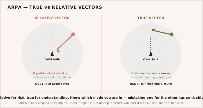
Rule 7 makes proper use of radar part of determining risk of collision, and Rule 6 makes its limitations part of safe speed. Both are examined.
- Small vessels, wooden boats and ice may not be detected at all. Radar does not see what does not return an echo.
- Sea clutter hides targets close to you — which is where they matter most. Tune it, and understand that tuning it out can tune out a small boat.
- Plot, do not eyeball. Rule 7 requires radar plotting or equivalent systematic observation. A glance at the screen is not a plot, and 'scanty radar information' is the phrase the rule uses to describe what you have.
- A constant bearing on the radar means risk of collision, exactly as it does visually.
Publications, at 200 miles
The Coast Pilot, the Light List, the Tide Tables, the Tidal Current Tables and the Notices to Mariners are the same books that served you inshore. What changes is that you can no longer look up and see the answer. Offshore, the publication is the information, and a chart corrected three years ago is a chart that is lying to you about something.