
Entry & progression
Exam module: Q160. The forecast is data. The decision is yours.
Pressure systems
| Low pressure (cyclone) | High pressure (anticyclone) | |
|---|---|---|
| Rotation (N hemisphere) | Anticlockwise, inward | Clockwise, outward |
| Air movement | Rising | Sinking |
| Weather | Cloud, precipitation, wind | Settled, clear, light winds |
| Isobar spacing | Often tight — tight isobars mean strong wind | Usually wide |
The single most useful thing on a synoptic chart is the spacing of the isobars. Close together means a steep pressure gradient, and a steep gradient means wind. You can read the strength of tomorrow's breeze off the chart before you read a word of the forecast text.
Fronts
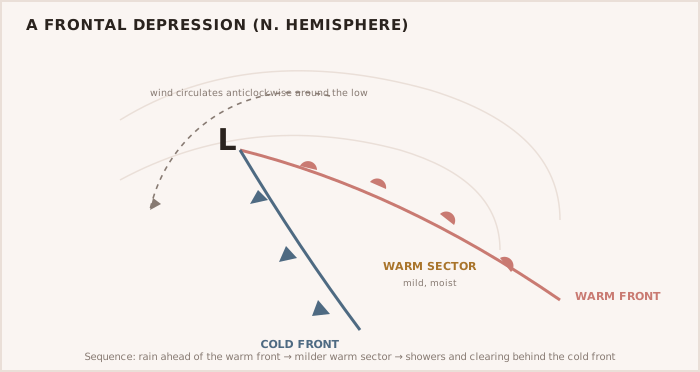
- Warm front — warm air riding over cold. Gradual approach, thickening and lowering cloud, steady rain, then a wind veer and a rise in temperature. Slow and visible.
- Cold front — cold air undercutting warm and throwing it up violently. Sharp: a line of heavy cloud, squalls, a sudden strong wind veer, then rapid clearing behind. This is the one that hurts.
- Occluded front — a cold front catching a warm front. Mixed and messy.
WARNING — The squall line at a cold front arrives in minutes A cold front does not ease in. The wind veers sharply and increases hard, often with a violent squall, and it can go from pleasant to dangerous in the time it takes to get passengers below. If the forecast has a cold front crossing during your trip, the front is your trip planner — not your schedule.
Buys Ballot's Law
Stand with your back to the wind in the northern hemisphere, and low pressure is on your left. It is a crude tool and a genuinely useful one: it tells you where the system is without any instrument at all, and therefore which way it is likely to move and what the wind will do next.
Fog
- Advection fog — warm moist air moving over a cooler sea. The sea fog that shuts down a coast for days, and it does not burn off with the sun because the sea is still cold.
- Radiation fog — a land fog forming overnight on clear calm nights. It drifts out over the water at dawn and usually clears as the land warms.
- Steam fog — very cold air over warmer water. Arctic sea smoke.
Fog is where Rule 19 replaces the give-way and stand-on rules, where your radar becomes part of a proper lookout under Rule 5, and where the sound signals of Rule 35 stop being an exam topic. Six passengers in fog is a genuinely hard afternoon. The best decision available to you is almost always the one you make before you leave the dock.