
Entry & progression
Exam module: Q171 — Navigation General. 50 questions, 70% pass mark. Codified at 33 CFR Part 62.
Region B: red right returning
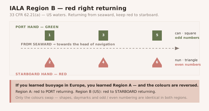
33 CFR 62.21(a): the navigable waters of the United States follow IALA Region B. Returning from seaward, red marks are kept to starboard. The mnemonic is Red Right Returning, and it is the right answer — though you will not find that phrase anywhere in the CFR.
NOTE — The US is not entirely Region B 33 CFR 62.21(a) carves out US possessions west of the International Date Line and south of 10° north latitude, which follow Region A — where the colours reverse. Only the colours reverse: 62.25(d) confirms that the meaning of daymark and buoy shapes is identical in both regions.
The lateral system
| Port hand | Starboard hand | |
|---|---|---|
| Colour | Green | Red |
| Buoy shape | Can | Nun |
| Beacon daymark | Green square | Red triangle |
| Number | Odd | Even |
| Light | Green | Red |
Numbers increase in the Conventional Direction of Buoyage (33 CFR 62.43(a)). Odd and even are not decoration — they tell you which side of the channel you are looking at even when the light has failed and the paint has gone.
The Conventional Direction of Buoyage
33 CFR 62.21(e): normally the direction in which a vessel enters a channel from seaward and proceeds towards the head of navigation. Where there is no route from seaward, it runs clockwise around land masses. In practice:
- Southerly along the Atlantic coast.
- Westerly along the Gulf coast, from Florida to Texas.
- Northerly along the Pacific coast.
Marks that are not lateral
- Safe water (62.27) — red and white vertical stripes; spherical buoy or octagonal daymark; Morse 'A' white light. Mid-channel; pass either side.
- Isolated danger (62.29) — black with red bands; two black spheres; Fl(2) W. Moor clear.
- Special (62.31) — solid yellow; yellow light. No lateral meaning at all.
- Preferred channel / junction (62.25(c)) — red and green horizontal bands. The topmost band gives the preferred channel; composite group flashing Fl(2+1).
- Inland waters obstruction (62.32) — black and white vertical stripes. Do not pass between the buoy and the shore.
- Information and regulatory (62.33) — orange geometry on white. Open diamond = danger; crossed diamond = exclusion; circle = restriction; square = information.
Two systems that break the rules
The Intracoastal Waterway (62.49). A yellow triangle means keep the mark to starboard; a yellow square means keep it to port — regardless of the aid's number, colour or light colour. A plain yellow horizontal band carries no lateral information at all; it merely identifies the aid as marking the ICW. This applies running the ICW southerly on the Atlantic and westerly on the Gulf.
The Western Rivers (62.51). Buoys are not numbered. Numbers on beacons show mileage from the river mouth, not lateral position. Green marks show a single flash; red marks a double flash. Isolated danger marks are not used. And the Western Rivers are the one place in the system where a white light does carry lateral significance (62.45(c)).