
Causes and the key terms
Tides are the rise and fall of the sea driven mainly by the gravitational pull of the Moon and, less strongly, the Sun. When the Sun and Moon are aligned, at new and full moon, their pulls combine to give the larger spring tides; at the first and last quarter they act at right angles and partly cancel, giving the smaller neap tides. Heights are measured above chart datum, which is set at or near the Lowest Astronomical Tide, so that the charted depth is almost always the least water you will find.
| Term | Meaning |
|---|---|
| Chart Datum (CD) | Reference for charted depths; near Lowest Astronomical Tide |
| Height of tide | Height of the sea above CD at a given time |
| Range | Difference between successive high and low water |
| MHWS / MHWN | Mean High Water Springs / Neaps |
| Drying height | Height of a feature above CD; it uncovers at low water |
| Key tidal datums and terms. |
Height of tide at a standard port
Using the tidal curve
- Take the day's high and low water times and heights for the port from the Admiralty Tide Tables.
- Enter the tidal curve diagram with the high-water height and mark the times of HW and LW.
- Mark the time you need, relative to high water, on the curve.
- Read across to the factor and interpolate between the spring and neap curves for the day's range.
- Depth of water = charted depth + height of tide; subtract draught for underkeel clearance.
Secondary ports — most harbours — are worked by applying tabulated time and height differences to the associated standard port, interpolating the differences for the actual range on the day. The same methods answer the two practical questions the OOW faces: what is the depth at a given time, and at what time will a required depth be available to cross a bar, enter a lock or take a drying berth.
Tidal streams
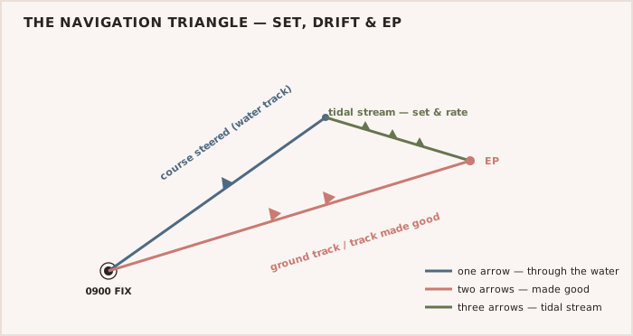
The horizontal flow — the tidal stream — is taken from the tidal diamonds printed on the chart or from a tidal stream atlas, both tabulated for each hour relative to high water at a standard port and given for springs and neaps. Each entry gives the set (the direction the stream flows toward) and the rate (its speed in knots), interpolated for the day's range. The stream is applied when working an EP and when finding the course to steer to make good a desired ground track.
WARNING — Datum discipline saves keels Charted depth is measured below chart datum; height of tide is measured above it. Confusing the two, or forgetting to interpolate for the day's range, is the classic tidal error that puts a ship aground on a falling tide.